En enestående indsigt i historien
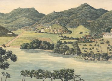
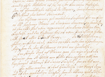
I næsten 250 år var Danmark kolonimagt i Vestindien. Helt unikt er der bevaret en enorm mængde beskrivelser, protokoller, breve og illustrationer, som giver en enestående indsigt i historien. For historikere, for det vestindiske og det danske samfund – og for alle de efterkommere, hvis forfædre var slaver, bosættere eller magtelite.
Læs historierne
I næsten 250 år var Danmark kolonimagt i Vestindien. Fra koloniens grundlæggelse i 1672 til salget til USA i 1917. Dette er en introduktion til aspekter af Dansk Vestindiens historie, som kan hjælpe dig på vej, både hvis du gerne vil vide lidt mere om emnet eller hvis du gerne vil søge videre i de digitaliserede arkivalier.
Søg i kilderne
Her kan du søge i ca. 5 mio. billedfiler af arkivalier fra Dansk Vestindien på tværs af Rigsarkivets databaser. De 5 mio. billedfiler af scannede arkivalier består af omkring 15.000 billedserier og indeholder 130.000 transskriberede poster. Inden du starter, så se her hvordan du søger.
Om projektet
I 2017 er det 100 år siden, at Danmark solgte de tre vestindiske øer til USA. Websitet markerer året ved at formidle de originale dokumenter og kilder samt historien om kolonitiden. Her finder du mere om websitets struktur, scanningen af arkivalierne, hvilke arkivalier fra kolonien der ligger i Rigsarkivet og andre steder, samt om frivilliges arbejde med at indtaste arkivalierne og dermed gøre dem søgbare.
Undervisning
Online materiale til historieundervisning i udskolingen. Se historiske kilder om den danske slavehandel. Der er kilder om køb af slaver i Afrika, sejlads over Atlanten og handel med slaver på de tre vestindiske øer.
-
 Personalhistorie
-
 Ejendomsforhold
-
 Slaveri
-
 Kolonimagt
-
 Handel og søfart
Temaer
Personalhistorie
Her kan du læse om befolkningen i kolonien. Dels om befolkningsudviklingen gennem kolonitiden, dels om registreringen af væsentlige begivenheder i det enkelte menneskes liv: Fødsel, vielse og begravelse.
Personalhistorie